Wednesday, August 2, 2023

Wake Wednesday: Raleigh Four Square - Early map of the original lay out of the Capitol City

Enjoy this excerpt of a wonderful map that is available in the North Carolina Collection at UNC. Printed in 1867, the full map shows Raleigh as it appeared in 1837. Here you see Raleigh in all its "four square" glory. That would be Caswell, Burke, Nash and Moore Squares. Only Nash and Moore are extant today.

source

Notice that the four streets perpendicular to the capitol building are wider than the others. This was planned. A note on the map states that "Newbern, Hillsborough, Halifax and Fayetteville Streets are ninety-nine feet wide; the others sixty-six. Each lot contains one acre of land." The full version of this map also shows businesses, landowners, property lines, and public buildings.

Be sure to view the full version of this map to read the inscriptions in each lot. There are lots of familiar early Raleigh citizens represented. It is also worthwhile to compare the full version to a current Google satellite map to see how things changed. Get the full verison here.


Tuesday, August 1, 2023

Follow Two Power Players to Improve your Genealogy Skills

Traditional Research 

Elizabeth Shown Mills is the one to follow. A legend in the field, she brings a wealth of ideas and know how to break through those brick walls. Catch her yearlong series at Legacy Webinars. If you are a subscription holder, you can access free. If not, this series alone is well worth the fee. You also want to follow her blog at Evidence Explained.com.

Genetic Genealogy Research

Diahan Southard is the hottest ticket in this field right now. She is everywhere and with good reason. She has a long history in genetic research and an amazing way of distilling a very complex subject into easy to understand small bites. Her blog is full of clear explanations, examples and short videos. Watch for her free webinars offered throughout the year and invest in your skills with her fee based learning including a skills workshop, YDNA course, Endogamy course and one-on-one coaching.


Visit Wake County Genealogical Society's Website - Homepage | WCGS Events | Join WCGS | Publications | Wake Cemetery Survey Images |Digital Resources | History Resources | More Links and Resources | Contact

Wednesday, July 26, 2023

Wake Wednesday - Historic Millbrook

Historic Millbrook was just up the road from my home when we moved to Raleigh in the 70s. It was like a toy town of paper Christmas houses. I was fascinated by it. I still remember going to this tiny one room Post Office.
I was so sad when it was leveled in the name of progress and I spent quite a while reminiscing over the photos and old maps on this blog post, another great one from legeros.com.
source


Friday, July 21, 2023

New Fall OLLI Schedule Offers Content of Genealogical Interest

Osher Lifelong Learning Institute (OLLI) at NC State opens it Fall 2023 registration Thursday, July 27. Our own Barbara McGeachy will follow her Intro Genealogy class with Genealogy: Intermediate Research Skills (Oct 24 - Dec 5).

Barbara notes that in addition to this class, there are several others that fit genealogy, local and family history, black history and Wake County interests. She shares the following information.

OLLI membership is required - minimum age is 50 and cost is $50/year plus the fee for each class. No affiliation with NCSU is required.  Almost all classes are held at the McKimmon Center in Raleigh between 9 am and 4:30 pm Monday through Friday.

  • Historic Preservation in Wake County
  • Battles of the American Revolution 1782-1783 is a six-week class; the instructor is so popular that he's teaching it twice 
  • Genealogy: Intermediate Research Skills taught by myself (Oct 24 - Dec 5).
  • Historical Black Neighborhoods of Raleigh
  • Wake County Enslaved Persons Project
  • Talkin’ Tar Heel: History, Voices, Culture, Legacy
  • The History and Evolution of the Outhouse
  • The Transnational Context of “1619”
  • Discovering the Dead at Oakwood Cemetery

OLLI offers classes that cater to a multitude of interests and genres. View their Fall 2023 course offerings here. There are other schedule viewing options at the OLLI schedule and registration webpage here


Visit Wake County Genealogical Society's Website - Homepage | WCGS Events | Join WCGS | Publications | Wake Cemetery Survey Images | Society Surnames | Digital Resources | History Resources | More Links and Resources | Contact

Thursday, July 20, 2023

Reminder - Next WCGS Virtual Meeting is Tuesday, July 25 - Special Pre Meeting Chat. Please, join us!

source


The Trail Through Penns Woods, Records of Colonial Pennsylvania with Sandy Rumble  

           Tuesday, July 25, 6:30 pm to 8:15 pm

Special Chat session - Please join a tad early for genealogy chat!  Topic:  Did your ancestors pass through Colonial Penn and where did they go from there?  6:00 - 6:30pm. Chat stops promptly at 6:30 to begin our program. Hope you can join us!

Get details and registration link at the Wakecogen events page.


Visit Wake County Genealogical Society's Website - Homepage | WCGS Events | Join WCGS | Publications | Wake Cemetery Survey Images | Society Surnames | Digital Resources | History Resources | More Links and Resources | Contact

Wednesday, July 19, 2023

Wake Wednesday - Hogg Dortch House

These photos certainly capture old Raleigh. Take a moment to appreciate the leafy grand entrance and oak filled lawn that graced the Hogg Dorch house in central Raleigh. The graceful old home sat on the block bounded by Wilmington, Lane, Blount and Jones Streets. If that location sounds familiar to you, it should. That is the location of the NC Archives building.

The home was built in 1850 by Dr. Thomsas Devereux Hogg. It originally filled the whole block.  The Union army may have housed officers here during the war while the troops camped on the grounds.

Descendants of the Hogg family lived here until Dr. Hogg's grandaughter, Sally, passed in 1951. In 1962 the grounds were razed when construction began for the Archives and History building.

Read more of the story at Olde Raleigh's Facebook page.

Hogg-Dortch home and grounds encompassed the full square
now occupiec by the State Archives, Freedom Park and the 
State Records Center.


Wednesday, July 5, 2023

Wake Wednesday - Reminiscence on Independence Day 1912 in Bloomsbury Park

"The Electric Park Amusement Company opened Bloomsbury Park on July 4, 1912. It was located at the end of the streetcar line near the Carolina Country Club, off what is today Glenwood Avenue in Raleigh, NC. It featured electric lights, a dance pavilion, a boating pond, penny arcade, roller coaster, and a magnificent Denzel carousel. Bloomsbury closed in 1921, and the carousel was sold to Pullen Park, where remains today."  -NCDigital

Can you feel the damp heat, hear the kids playing, hear the sounds of the calliope playing appropriate patriotic tunes.  Check out the Bloomsbury Park album at the NCDigital Flickr account to see what Idependence Day celebrating was like in 1912.


source

Visit Wake County Genealogical Society's Website - Homepage | WCGS Events | Join WCGS | Publications | Wake Cemetery Survey Images | Society Surnames | Digital Resources | History Resources | More Links and Resources | Contact

Wednesday, June 21, 2023

Wake Wednesday - Raleigh's First Suburbs ca.1900

Something is pulling my attention to Raleigh/Wake County around the turn of the century (1900's). It was a time of accelerated growth and prosperity. Perhaps it is that parallel that with today's frantic growth pace that has me looking backwards.  

I started looking at the historic neighborhoods that built up in the early 1900's:

  • Glenwood  - c.1905. It's development a direct result of the streetcar line providing access north and west.
  • Boylan Heights -  c.1907. Built on 180 acres of the William Montfort Boylan Mansion on the western outskirts of Raleigh.
  • Cameron Park - c.1910. Built on land that half a century earlier was Cameron Plantation.
  • Bloomsbury - c. 1914. It's construction signaled the transition from streetcar access to automobile access as Raleigh expanded ever outward.

Trolley time in Raleigh (source)

As I did more research, I
 became amazed and a little unsettled at the historical, cultural and sociological details that are unearthed when you start to read about them. What started as a curious and nostalgic look at some quaint Wake communities lead to a whole different perspective on Raleigh as it emerged into the 20th century. (The links above will take you directly to individual historic profiles for each neighborhood.)

I was going to do several posts on these lovely nostalgic neighborhoods and their role in the changing mores of Wake County. As luck would have it, my research led me to someone else with the same interest in these communities who had already covered this topic in full detail and really honestly. So rather than "re-invent the wheel," I will now direct you to the well written blog post, City of Oaks by blogger David Fleming.  While I am mainly interested right now in the Raleigh communities that sprung up right after 1900, David has covered the development of Raleigh in its entirety. This will necessitate some scrolling on your part to bypass the original layout of Raleigh and the stagnation of growth around and after the Civil War years.  The part that I am most interested in about a quarter way down the page just after he discusses Josephus Daniels. 

He starts with pretty much the same jumping off point that I had arrived at - the building of the streetcar line on Glenwood Avenue and how it both enabled and depressed parts of Raleigh's population. Like I said, some of this is unsettling, but he does present a thorough unvarnished look the racial divide and class isolation that grew through the first half of the 20th century.

David's post is filled with wonderful photos, maps, historic perspective and even some useful statistics. If times allows, read the whole article and take in the massive amount of work that David has done here.


I am sure grateful for his efforts. I could not begin to present the subject as well as he did.

Update:
I have recently found another reminiscence from a Mr. Howard Lake on an old Rootsweb post. The post is here if you want to read it in the original format. Caution - black background, multicolor text, and frequent font changes in the original. It is a shame to lose such valuable content that preserves how things were - 


My Uncle Samuel Holland (1917-1990), who grew up at 202 Linden Avenue, built a little trolley car from the street down the hill where the Baha'i Unity Center is now located. It would roll down the tracks and then be hauled back up by a rope. All the neighborhood children used to play on the trolley.
Raleigh itself had real trolley service. One line went from downtown to Bloomsbury Park at the end of Saint Mary's Street. Nothing remains of Bloomsbury Park, except the post for the merry-go-round that was restored and is now enjoyed by children at Pullen Park.  Bloomsbury is now a residential area, and was between Aldert Root School and the intersection with Lassiter's Mill Rd.  This explains why there is that weird switch in the names of the roads, a frequent occurrence in Raleigh.  It used to be the jumping off place for the city limits, but is now some 8 miles inside Raleigh.  Just to finish up my blabbing, we have been blessed with an excellent economy for the last 50 years.  Our unemployment rate is about 2%, and has rarely gone over 5%.

Raleigh's early years of the twentieth century was the creation of three planned suburban neighborhoods, Glenwood, Cameron Park, and Boylan Heights. All three of these suburbs were platted between 1906 and 1910 on lands situated to the north, west, and southwest of the 1907 expanded city limits. Although the neighborhoods were designed to attract Raleigh's newly arrived or those newly ascended to the middle class, they vary in their layout, architecture, and topography. From the outset, these neighborhoods had water and sewer services, electric power and access to streetcar transportation which were vital amenities to the new city dwellers. 
 
In addition to the white suburbs, black residential expansion continued at an unprecedented rate in the south and east sections of Raleigh. South Park, bordered by Bledsoe, Wilmington, Hoke and East streets, was platted in 1907 by the white-owned Raleigh Real Estate and Trust Company. Soon after, in a twelve month period, 122 lots had been sold and were in various states of improvement. Farther to the north and east, around St. Augustine's College, two other black suburbs were created in the early 1910s. Battery Heights and College Park attracted skilled workers and a rising middle class sector. The domestic architecture consists of one and two story frame Triple A's and shotguns, cottages and I-houses decorated in a variety of styles. Although South Park, Battery Heights and College Park were in outlying areas, by 1920, streetcar service along Hargett Street was extended and an increased use of automobiles attracted would-be homeowners.

Besides providing improved access to the outlying residential areas, the Carolina Power and Light Company (CP&L) sought to expand its ridership base. In 1911, the utility extended northward the Glenwood Avenue route to the Carolina Country Club which bordered a one hundred acre park. Bloomsbury Park opened in 1912 and featured an electric powered carousel, a roller coaster and a penny arcade. The general manager of CP&L reported, "we now have a long railway line for joy riders which terminates at the park and we are hopeful that the combination will prove most beneficial to us". By 1915, however, Bloomsbury Park had ceased operations, terminated by CP&L. The carousel was bought by the city and placed in Pullen Park. What was left along both sides of the rail lines was mainly farmlands filled with cultivated fields, fallow expanses, and woods that had been ogled by every paying passenger up to that time. In mid-decade, continued residential expansion occurred when large plots of land were purchased by Thomas Ruffin, James H. Pou, and others. Situated north of the Five Points intersection, the lands would beckon to prospective homeowners for several more years until the outbreak of World War I temporarily suspended development.

As towns became cities and citizens longed for the open spaces and trees of pre-industrial communities, recreational parks became a part of the urban landscape. Pullen Park, a gift of eighty acres from businessman Richard Stanhope Pullen in 1887, became a site where Raleighites could picnic, boat, skate, and enjoy nature. Bloomsbury, also at the end of a trolley line and built in 1912 by the Carolina Power and Light Company, was advertised as the Electric Park Amusement Company and provided diversions associated with amusement parks today, such as roller coasters, penny arcades, and merry-go-rounds. A carousel, built by the Dentzel Carousel Company of Philadelphia (1903-9) and featuring the handcarved animals of Salvatore Cernigliaro, was among the most popular features of Bloomsbury Park.

According to one writer, "Raleigh was stung by the report that Charlotte had beat it to electric car service." Dr. S. J. Jacobs of Iowa purchased the existing streetcar charter and announced ambitious plans. Arrangements were made for Edison General Electric Company to furnish electrification and four elegant trolley cars to be purchased from Philadelphia. Disputes developed between the owners and construction company, and some electric wires were removed. To resolve matters, Baltimore bondholders became involved, and Raleigh residents bought $50,000 in bonds to finance construction of the streetcar system. When he became unable to pay a bill for machinery, Dr. Jacobs quietly left Raleigh and never returned.
The Raleigh Street Railway Company, however, began scheduled runs on September 1, 1891. The system covered the same general route as the mule-drawn system. From downtown, the tracks ran west along Hillsboro Street (now Hillsborough) as far as St. Mary's College, north on Blount Street to Brookside Park near Oakwood Cemetery, and down Fayetteville and Cabarrus streets to the depot southwest of downtown.  When the company failed in 1894, James H. Cutler of Boston, who already had streetcar interests in Asheville and other southern cities, acquired more investors and reorganized the company as the Raleigh Electric Company.

Carolina and Power & Light Company, organized in 1908 in Raleigh, incorporated Raleigh Electric and its streetcars, other area utilities, and the newly built Buckhorn dam and plant on the Cape Fear River. Only Fayetteville Street, of all the streetcar routes, was paved at the time.  Frank Shearin, a conductor, recalled, "People in the residential areas used to complain about the dust." To solve the problem, CP& L bought a 4,000-gallon capacity tank car to water down the roads. This was only one example of how CP& L invested the necessary funds to modernize Raleigh's streetcar operation.  

By 1915 the system boasted twelve miles of trackage. It served the state technical college (now N.C. State University) and reached the State Fairgrounds, ran along New Bern Avenue to the east, and in (1912) arrived at the new 100-acre Bloomsbury Park out Glenwood Avenue to the north.  As a student at N.C. State in the early 1930s, Willie York (developer of Cameron Village Shopping Center and other properties) recalled riding streetcars downtown to the California Fruit Store to meet girls from Meredith College.

In June 1888, the Raleigh Street Railway Company opened Brookside Park just north of the city near Oakwood Cemetery, connected to the mule-drawn streetcar system by a spur track. Baseball was a major attraction, along with a merry-go-round and picnicking. The same year, the city opened Pullen Park on the western edge of the city. Brookside Park was developed to a greater extent than Pullen, probably because it was  privately owned and on the streetcar line. By 1912 Raleigh was growing fast and there was no room to expand Brookside. CP& L, at that time owner of the city's electric streetcar system, opened Bloomsbury Park on 100 acres located three miles out Glenwood Avenue. Using 8,000 lights, the park was nicknamed the "electric park." The park's features included an octagon-shaped pavilion where orchestras played for dances; a Dentzel carousel with a Wurlitzer organ, costing $12,000; a roller coaster; and a penny arcade.


Thank you Mr. Lake. We've got to keep these old memories alive! 

Update: View early maps of Raleigh's first Suburbs from the Wake Register of Deeds Consolidated Real Property Index that was highlighted in last week's Wake Wednesday post. Find these areas on Google Maps by looking up street names and compare the changes that you see today!

Glenwood (not found in BM1911, BM1915, BM1918)

Boylan Heights1, Boylan Heights2

Cameron Park1, Cameron Park2

Bloomsbury


Visit Wake County Genealogical Society's Website - Homepage | WCGS Events | Join WCGS | Publications | Wake Cemetery Survey Images | Society Surnames | Digital Resources | History Resources | More Links and Resources | Contact


Wednesday, June 14, 2023

Wake Wednesday: Can you name the Freedman's Villages of Raleigh?

Sometimes when I decide to write about a particular topic, in my research I find that one or several other persons have already covered the subject so well that there is not much that I can add to the conversation except curiosity. That is the case here, so bear with me.

A recent conversation with some friends started with cemeteries (because that is where all conversations with me seem to start these days…), settled on black cemeteries and then veered over to the Freedman's villages in Raleigh. 

If I asked you to name some Freedman's villages in Raleigh, could you? 

Many people could name Oberlin Village. A few others could add Method. 

These are only two of thirteen Freedman's villages that sprang up around postbellum Raleigh in the late years of the Civil war and in the years immediately after. Blacks, no longer enslaved and with little to no livelihood, fled to Raleigh (and other large cities across the South) seeking refuge from hostility, jobs and assistance from the US Army and the Freedman's Bureau. 

Oberlin and Method remain. Oberlin as a Historic Preservation site and the grounds of Method can still be walked, observed and appreciated dispite the struggle of a loyal few supporter to keep the Method heritage alive.The history and physical evidence of the rest of these villages has been all but erased in the face of progress. 

A friend had shared a handout that fueled my curiosity. That handout was from a lecture by Carmen Cauthen, a writer specializing the Raleigh's historically Black communities. I suspect the handout came from the lecture captured on the YouTube link mentioned below. It listed the thirteen villages. The list included:

Lincolnville - destroyed to build the NC A&M College

Brooklyn - near St. Augustine

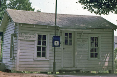
Method (formerly Masonville) - southwest Raleigh.

Oberlin - now a historic preservation site

Nazareth - the site became the Catholic orphanage and now the new cathedral

Idlewild - split by the building of New Bern Avenue into Idlewild and Cotton Place

Old Fairground - (south of St Augustines)

Hayti - (near Washington School)

Cannon Lands - formerly Robert Cannon estate

Hungry Neck - downhill from the Capitol

St Petersburg - a portion of Govenor Manly's extate

Smith-Haywood - south of Raleigh

Wilmington/Blount - near Oakwood

Manly - on property of Gov. Charles Manly

Carmen Cauthen's lecture on YouTube, "The History of Housing in Raleigh," references the thirteen Freedman's villages with some great maps running from about 8 minutes in until 15 minutes.The video is a much more broad look at housing that is worth watching.

It is very easy to find details about Oberlin and slightly more challenging to find information on Method. The rest are fairly difficult to find anything written, but I did manage to find a few articles which mention Freeman's villages which I will share with you. 

These descriptions and approximate locations above were gleaned from a document from the Historic Preservation Office. See "The Evolution of Raleigh's African-American Neighborhoos in the 19th and 20th Centuries," by Richard Mattson for a much more in depth picture of the villages and their place in history.

Also, the National Register of Historic Places document prepared for Oberlin Village contains some comparisons to the other villages along with historical and cultural context of the time period.

This birds-eye map of Raleigh from 1872 may help anchor the locations into the landscape back then.

Lastly, I did manage to find a great post by Heather Leah. See Heather's post here. You will find location descriptions that are much easier to visualize with landmarks from today.

Update and question --
Does anyone know the names and whereabouts of Freedman's Villages in the rest of Wake County? I have located one more through the Wake Cemetery Survey - Shiloh near Morrisville. I am sure there are others. If you can get me started on this search,  please send me details of FVs in the more rural parts of Wake County. Credit will be given and the help is much appreciated. Thank you in advance!


Wednesday, June 7, 2023

Wake Wednesday - Highlighting Wake County Historic Maps accessed though the Wake Register of Deeds

 Here is another great find that resulted from researching the Wake Cemetery Survey project

A large number of historic maps have been scanned and put on line by the Wake County Register of Deeds. The restored and peserved historic maps are available in the Online Consolidated Real Property Index. Currently available map time frame spans years 1885 to 1927

To View Preserved Historic Maps Online - Follow the Instructions Below:

  • Visit: https://rodcrpi.wakegov.com/booksweb/genextsearch.aspx
  • Enter one of the BM Years into the Book field one of the following years.
    In the Page field enter %


This collection is extremely useful for tracking changes to an area over time and locating buildings or landmarks that may no longer exist. Here is an example map from 1913.


It is interesting to see what is the same and what has changed in the ensuing years. Notice how the original small lot sizes have been absorbed and the whole area is now large commercial eneavors.
Where the original market site covered roughly one eigth of the square, the current City market encompasses four full blocks of space. Notice that what was once Pullen Street is now Wolfe Street. 

There are so many maps to browse. Set aside a bit of time to go exploring and comparing. 

Heather Leah's article for WRAL on this map collection is very interesting. Click this link to read more about the wake county historic maps at the Register of Deeds office.

Wednesday, May 31, 2023

Wake Wednesday - William Hill General Merchandising Store c. 1806

On Nov. 19. 1806, Hartwell Parrish, John S. Robeteau, Dury Brown, Isham Utley and William Spright, Jr conducted business at the William Hill General Merchandising Store. This account appears in an abstraction of the original ledger in the Wake Treasures Journal. This abstraction of the ledger Contains 250 pages, approximately 2500 names, and activities from November 1806 to March of 1807. The abstraction is divided into three parts appearing in Vol. 1, Issues 2, 3, and 4.

If you had Wake County ancestors living in the area in the early 1800's, this may be a record set you want to check out.

image source  (not original to Wm Hill ledger)

Journal access is a great perk of your Wake County Genealogical Society membership and a handy tool for those researching in Wake County remotely. Members have 24/7 access to the Journal. With 20 plus years of content, you will likely find the surnames and place names you are researching. Access the Journal issues directly in the Member Area after log-in.

This content is referenced with permission of Journal editor.


Visit Wake County Genealogical Society's Website - Homepage | WCGS Events | Join WCGS | Publications | Wake Cemetery Survey Images |Digital Resources | History Resources | More Links and Resources | Contact


https://melstampz.blogspot.com/2011/03/happy-weekend-ledger-freebies.html

Tuesday, May 30, 2023

Celebrate Memorial Day by Researching your NC Ancestors' Military Records

Memorial Day, originally called Decoration Day, began during the American Civil War when citizens placed flowers on the graves of those who had been killed in battle. After World War I, it came to be observed in honour of those who had died in all U.S. wars, and its name changed to Memorial Day. (source)


While modern tradition has us observing Memorial Day on the last Monday in May, from 1868 to 1970 it was observed on May 30 each year. Most of the free search days at the pay sites will have expired by now, but you can continue to honor your soldier ancestors with research using these free resources. Enjoy.

Discover the military stories of your Wake County and North Carolina ancestors with the help of this list.

Raleigh National Cemetery page at Veteran Affairs.gov -  general information page - includes a  map and search tool, and information brochure on the history of Raleigh National Cemetery.

Raleigh National Cemetery page at Find A Grave - includes 5,910 memorials.

Historic Confederate Cemetery at Oakwood Cemetery - webpage with contact info and hours of operation.

The Confederate Cemetery was included in the Wake Cemetery Survey c. 1978. The file is here and includes 59 pages of grave listings. This may be helpful as a look up tool before going to the Find a Grave site as the Confederate Cemetery is included with all the other listings. Find a Grave states that there are 1500 Confederate soldiers buried there.

WW2 County War Records finding aid, NC Archives, Military Collection - All counties. Wake County begins on image 90.

NC Military Records at FamilySearch Wiki - covers all wars from colonial times to Viet Nam, includes forts and brief descriptions of each war with resources included.

NARA National Personnel Records Center - Order military personnel, health and medical records stored at NPRC. Process details and necessary forms are here.

Military Records at NCGenWeb - various muster rolls, records, images, US Colored Troop Regiments. (note- there are a few broken links, but included for the ones that do work.)

North Carolina Military Records at LDS Genealogy - Included for the vast array of links pertaining to all facets of military history with online records clearly marked.

North Carolina Military Records Research Guide at Random Acts of Genealogical Kindness - extensive list of resources curated by war/time period. 

This NC military Rootsweb page is included for the links to all the National Cemeteries in NC.

I hope someone finds a useful clue in these records. 

"Those who have long enjoyed such privileges as we enjoy forget in time that men have died to win them."- Franklin D. Roosevelt


Visit Wake County Genealogical Society's Website - Homepage | WCGS Events | Join WCGS | Publications | Wake Cemetery Survey Images |Digital Resources | History Resources | More Links and Resources | Contact