Showing posts with label wake county maps online. Show all posts

Wednesday, May 15, 2024

Wake Wednesday: What did Wake County look like before all the development?

Just look at this wonderful postal map of turn of the century Wake County. It will certainly help you visualise a quieter, more pastoral Wake County. I used this map recently to determine the location of a cemetery in the relocation zone of Falls Lake. Things look so different now. 

Roads displaced by Falls Lake

This map is available online from the North Carolina Collection at UNC. This is a rural delivery route map circa 1910 - 1919. It covers the whole county and provides a context that is just not available to us today. Take a look. Keep a link handy. 

Source: Wake County c.1910-1919, US Postal Delivery Routes


I bet you will be visiting this map as often as I will. 


Visit the Wake County Genealogical Society - Homepage | WCGS Events | Join WCGS | Publications | Digital Resources | History Resources | More Links and Resources | Contact

Wednesday, November 1, 2023

Wake Wednesday - Map of Wake County - Fendol Bevers 1871

Someone was asking about the specific location of the Wake County Home the other day. I knew I had seen it on a map in the past so I went looking. I spent a few minutes looking through the digital map collection at UNC and found the map I remembered.

In the process of finding that map, I ran across this one which is a gold mine for Wake researchers. The Fendol Bevers map from 1871 includes a wealth of information. The abstract that accompanies the map decribes it this way:
Map drawn from actual surveys of Fendol Bevers, County Surveyor. Inset of City of Raleigh, Table of Population and other information by townships, description of townships reported in margins. Townships designated in color. Map shows townships, landowners, churches, retail stores, schools, mills. Townships shown include Raleigh, New Light, Oak Grove, Barton's Creek, Wake Forest, Little River, Cedar Fork, House's Creek, St. Matthew's, Mark's Creek, White Oak, Swift Creek, St. Mary's, Buckhorn, Middle Creek, and Panther Branch. The Raleigh & Gaston Railroad and the North Carolina Rail Road are shown.
click to view larger

I could spend days with this map, maybe months... researching all the local interest here. Just look at all the names and locations. Locations of homes, churches, farms and millls. Are your ancestors represented here. Can you share stories of some of these old places? If so, please let me know. I know there are folks that would love to here these stories.

In the meantime, enjoy a pleasant afternoon browsing the map and reminiscing about places and days gone by. View the map it its beautiful entirity here.


Visit Wake County Genealogical Society's Website - Homepage | WCGS Events | Join WCGS | Publications | Wake Cemetery Survey Images | Society Surnames | Digital Resources | History Resources | More Links and Resources | Contact

Wednesday, June 7, 2023

Wake Wednesday - Highlighting Wake County Historic Maps accessed though the Wake Register of Deeds

 Here is another great find that resulted from researching the Wake Cemetery Survey project

A large number of historic maps have been scanned and put on line by the Wake County Register of Deeds. The restored and peserved historic maps are available in the Online Consolidated Real Property Index. Currently available map time frame spans years 1885 to 1927

To View Preserved Historic Maps Online - Follow the Instructions Below:

  • Visit: https://rodcrpi.wakegov.com/booksweb/genextsearch.aspx
  • Enter one of the BM Years into the Book field one of the following years.
    In the Page field enter %


This collection is extremely useful for tracking changes to an area over time and locating buildings or landmarks that may no longer exist. Here is an example map from 1913.


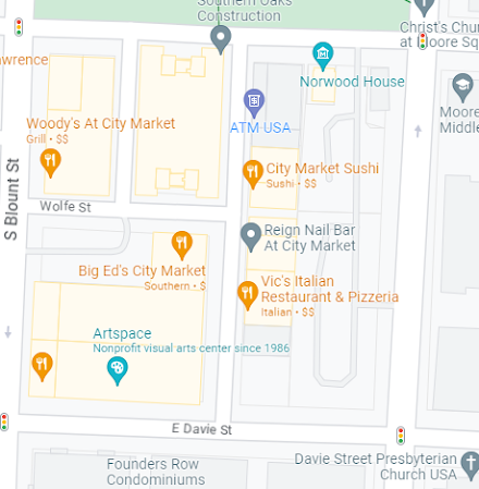
It is interesting to see what is the same and what has changed in the ensuing years. Notice how the original small lot sizes have been absorbed and the whole area is now large commercial eneavors.
Where the original market site covered roughly one eigth of the square, the current City market encompasses four full blocks of space. Notice that what was once Pullen Street is now Wolfe Street. 

There are so many maps to browse. Set aside a bit of time to go exploring and comparing. 

Heather Leah's article for WRAL on this map collection is very interesting. Click this link to read more about the wake county historic maps at the Register of Deeds office.

Wednesday, March 25, 2020

Wake Wednesday - Olde Raleigh c.1797

I had a great time last night listening to the WCGS online presentation in lieu of a face to face meeting. I hope many of our members took advantage of this experimental project. David McCorkle showed us many sources for historical maps and many new technologies to bring these maps to life. 

One of the maps early in David's presentation was a map of the very early city of Raleigh. I found this map captivating. This is one of the wonderful maps in the UNC North Carolina Maps Collection. In addition to the handrawn roughness and aged patina of this map, the maker had taken the time to draw the houses and shops in their respective locations. Zoom in enough, and you can take a stroll down old Raleigh streets in your mind. Here is your ticket to time travel - Plan of the City of Raleigh with all the improvements & all the Numbers july 1th, 1797


source

PS - if any of you had trouble logging into the presentation last night, please let us know. Email me and I will forward to David. This remote presentation is a new process and still being worked out. Your feedback will help.

Return to the WakeCoGen Website